
|
I was still on a natural high after experiencing what I can only describe as insane long duration unbroken thunder for over an hour in the Cookstown area the previous day. Severe elevated thunderstorms had impacted the Mid-Ulster area for hours resulting in flash flooding and power outages, it was the most intense thunderstorm activity I had ever experienced during the month of September. I honestly thought I had seen it all storm-wise during this epic season however this was something entirely unexpected which took things to the next level. I reckoned that this was a fitting end to a wonderful convective Summer, however it wasn't quite over yet. I knew the following day was showing potential and perhaps the day after also, I hadn't studied those set-ups in detail, that would wait for the next morning. To be honest, I'm a structure person, even though Thursdays thunder event was remarkable I was craving something photogenic on camera just to finish the season in style, could nature do it one more time?
Friday September 8th was a day exploding with 'potential', however that potential had a low chance of happening. We were in the middle of a late season heat wave and our weather was under the influence of high pressure. This particular pattern had opened the gates to a very moist unstable Sly plume event which was advecting big energy across Ireland and N. Ireland. The local television weather forecasts were addressing the heat wave and spoke with confidence that this day had the potential to beat our all time temperature records. The Met Office website showed a dry day with blazing sunshine with no rain at all however in their text they did mention the small chance of a shower or rumble of thunder but it was obvious that confidence was very low and as usual their graphics and text contradicted themselves with no clarity at all.
GFS and other models were showing between 1000j/kg and 1600j/kg of CAPE, locally higher, present across N. Ireland for the entire day, furthermore I noticed with great interest that the CAPE remained well beyond 21.00 and even persisting to midnight across inland regions, something which I had never seen before during September for here. Other models struggled to show precip at all so it looked a day that could be strongly capped with the consensus being that it would be dry and sunny for everyone, the risk of rain was so low it wasn't even being addressed on the television forecasts at all. However, my attention was drawn to the AROME model, I was shocked to see it showing several big cells firing late in the day, in particular it showed a strong red core over the Sperrins to the W of Cookstown during the late evening, I wondered if the AROME was onto something? maybe the cap was going to break later? it seemed like a long shot but something in my gut was telling me to be on alert.
The day was very warm and extremely humid with relentless sunshine, it felt like June all over again and most definitely felt like a storm day to me, the high dew point of the air on my skin had that same sensation I had experienced during every other big storm day this season. As the day went on the radar was blank with not a cloud in sight, meanwhile the uncomfortable humidity became very notable, yet again unlike anything I had felt before for this time of year, even just standing still felt sweaty, this to me was a big clue that the atmosphere was priming itself. I got chatting with our convective forecaster Owain Rice who said he noticed disturbed cumulus on sat imagery to the SW, he agreed the cap was very strong but his calculations showed that we would need a temperature of around 30 degrees C to break the inversion, that seemed like a bit of a stretch to me and I was already considering this day a bust. However Owain is always an optimist, if he can see any potential at all for a storm he will address it, he did mention that the cap breaking temperature threshold might lower late in the day and also the cloud top temperatures showed a little more cooling later on, this in addition to a sea breeze convergence zone and perhaps lift from higher terrain could help the cap breaking process.
I got a visit from photographer Nigel McFarland, we sat out in the back garden under an umbrella for shade chatting about photography and drones. His van was reading very high temperatures on the way down, we noticed a sudden increase in small fleecy cumulus approaching from the S, they looked like delicate pieces of cotton wool and were not gaining in vertical height so it looked like the cap had won. Then during the late afternoon we reached an all new N. Ireland temperature record peaking at 28 degrees C over Co. Tyrone just to the W of my location, that was astonishing. With the radar quiet and the sky behaving itself I went out for dinner with Roisin and my Dad, I was a little anxious that I might miss something while in the restaurant so I brought my gear with me just in case, also if anything did happen it would likely be later anyway.
We settled into a relaxing evening with a nice dinner in town, I don't often eat red meat anymore but I did have a delicious burger which went down well, the air conditioner above us kept us nice and cool. During the dinner I had a strong instinct that something was going to happen so I took a look at radar on Roisin's phone, I was shocked to see a massive thunderstorm far below the border over the N midlands, it was actually over Co. Meath and was composed of a line of huge red cells indicating a mature multicell was in action, the radar showed prolific lightning rates, the cap had broke, Owain had been rite yet again! That storm was putting on a spectacular show in the Republic, we soon began seeing images posted on social media which made me jealous, it looked like a scene from Europe or the Tropics, not only was the cell massive in height, it also sported stunning solid updraught structure which fed into an enormous anvil spreading across the entire sky, images were coming in from all over the country, it was seen from so far. N. Ireland looked dry on radar so perhaps that was the event of the day so I chilled out with Roisin and Dad.
Half an hour later I began to feel agitated as if something was going to happen, I had another look on radar. The Meath storm was still flashing away while moving slowly N but I also noted the presence of a few weak showers in N. Ireland, one at the border the other over the SW Sperrins, that was interesting, five minutes later and the next update showed red cores in those showers, literally from green to red in five minutes, things were happening, it was time to go, it was approx 20.30, perhaps the AROME had been onto something the entire time. When we stepped outside the restaurant it was like walking into a sauna, cool and shade into bright warm humid air, the contrast was unreal, Dad said he never remembered feeling like this in September before, especially this late in the evening.
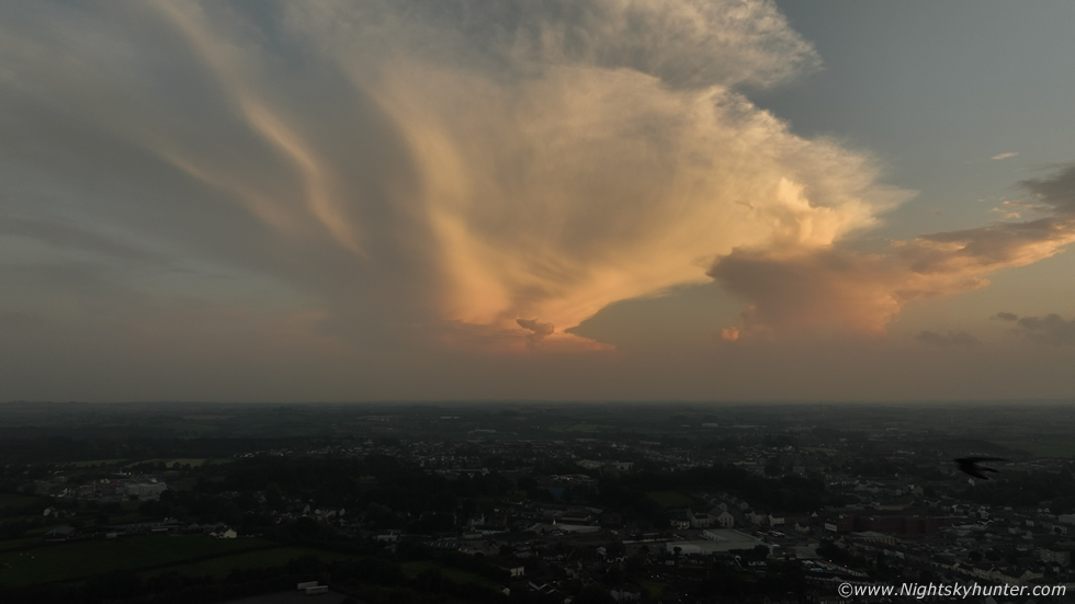
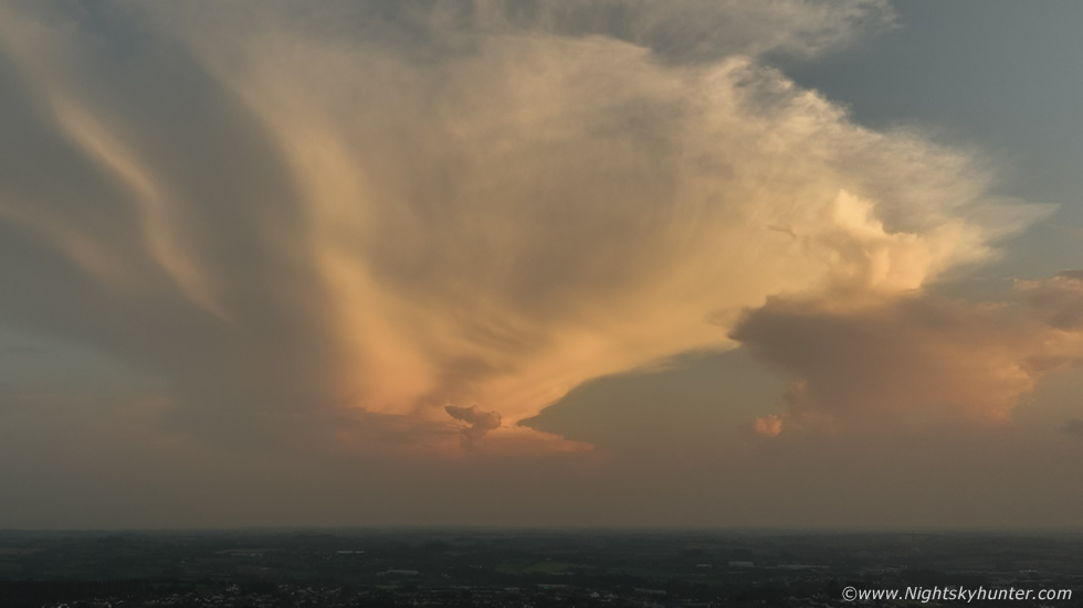
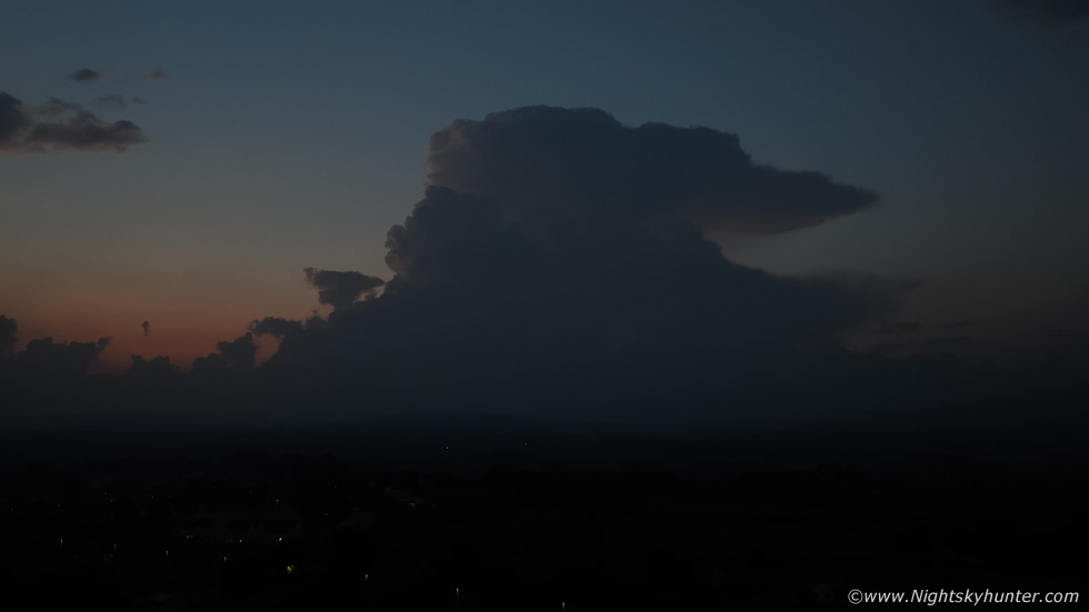
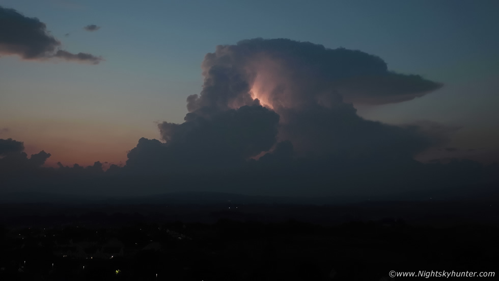
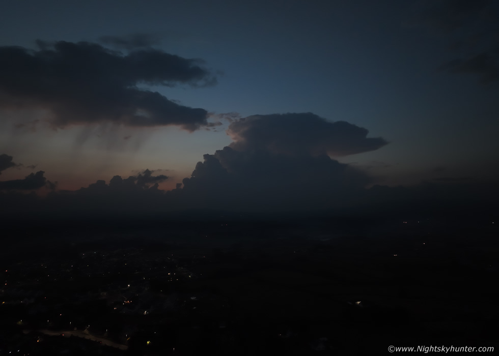
As we made our way back we began to get glimpses of the sky and when we did we were shocked again as the pre-sunset was a place of absolute beauty. I could see a line of dark towers far away to the W/SW, those must have been those cores on radar, and to my S was a massive anvil visible to anyone who cared to look, Roisin spotted it immediately too and knew that it was exceptional, as we drove I kept glancing out the window to the W, that big dark tower was getting back-lit by the setting sun, but some sunlight was catching the updraught on its back edge, the result was a black cauliflower with a sharp rose-red tinge all around it's outline, it was gorgeous! - the sky was talking big time.
 |
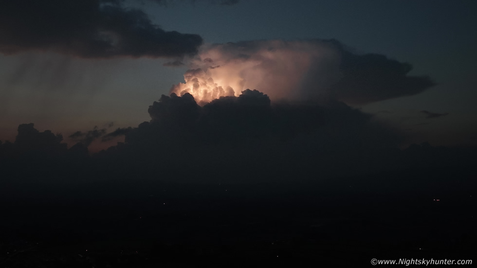
We arrived back home, I quickly went online to the chat to inform the guys that I was seeing a massive tower here and that things were happening. Colleen Webb and Nigel McFarland where in the Gortmore area on the N coast watching it approach, John Fagan was also driving to the coast and seeing the same scene I was, he planned to intercept it there also and Paul Martin had eyes on the sky from Omagh. From my position the updraught was moving NE across the Sperrins, it would pass W of Cookstown exactly as the AROME had showed, I decided I would get the drone up for a better look, also I wanted to get a record of that sunset sky.
Drone at 120m facing S, it then dawned on me what I was looking at, this was the incredible anvil on that monster multicell storm which had been over Co. Meath! that's the storm over the Republic of Ireland, I was astonished, the anvil would have been sheared N/NE so I would be viewing the storm almost face-on here, the anvil had fully spread throughout the Tropospause, it looked like a volcanic eruption, the main updraught and flanking line would have been out of site behind the anvil to the S/SW. When I saw this anvil with my own eyes it really hit me what a significant cell they had got.
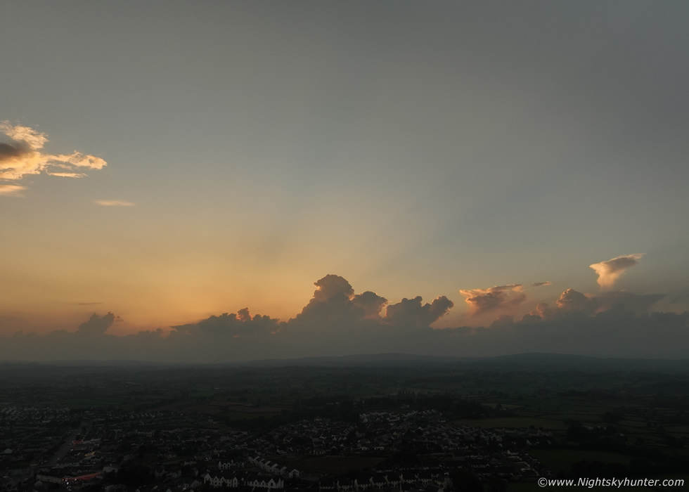 |
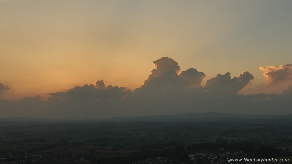
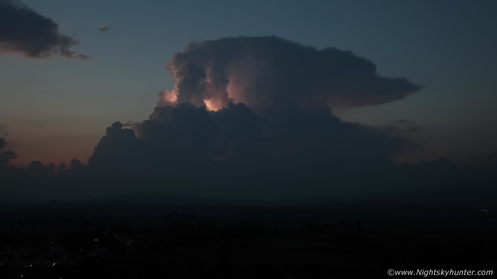
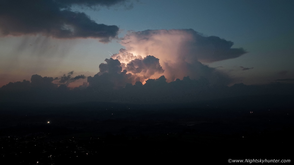
Panning the drone to the W provided me with a good view of the tower I had spotted while we where driving home. The sunset sky was a beautiful scene, the sky had that widespread orange afterglow look, similar to a classic high pressure weather event, thick with haze and perhaps the remnants of the recent Saharan dust. Long crepuscular rays fanned across the skyscape for 80-100 degrees as the last rays of the setting sun on the horizon caught the tops of this growing convection.
 |
A final look back to the S. I still couldn't believe this was a storm far away below the border
 |
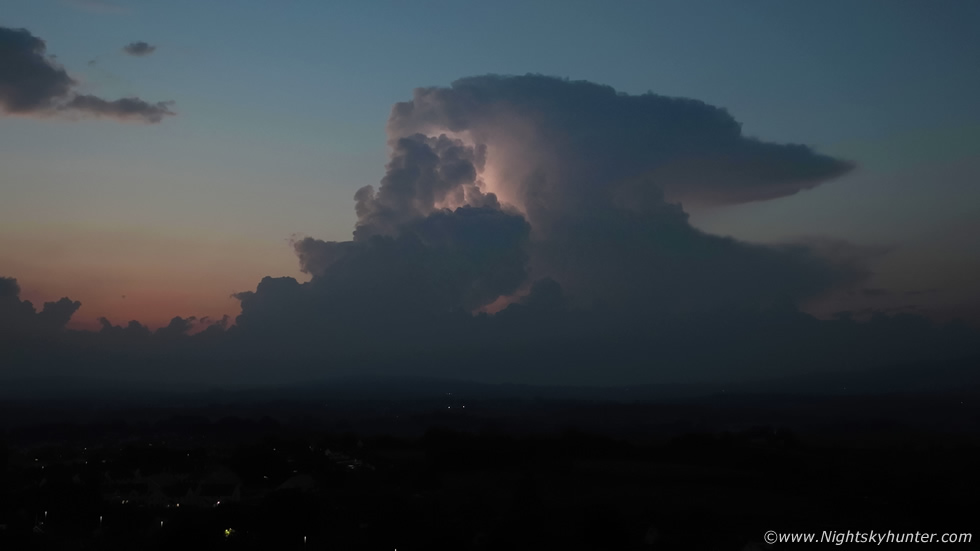
Back to the W I could see this tower bubbling rapidly on the screen, I was convinced it was literally breaking through the cap as I watched. If it was it would be tapping into 1000-1600 CAPE and 20-25 knots of deep layer shear, my battery was getting low so I landed the drone and went back inside to show Roisin. I was sweating in the heat, our room was stifling even with the doors and all the windows open, I switched over to a new battery then checked radar, that tower was now a big red core and it was producing lightning!, regular lightning!, what do do? it was already well after 21.00, by the time I drove out and found a good view point to shoot it with the DSLR it may have moved on, I didn't want to waste time, maybe I should just put the drone back up again and test out the large four thirds sensor on the Mavic 3 and see what it could do in low light, Roisin said ''go for it''.
 |
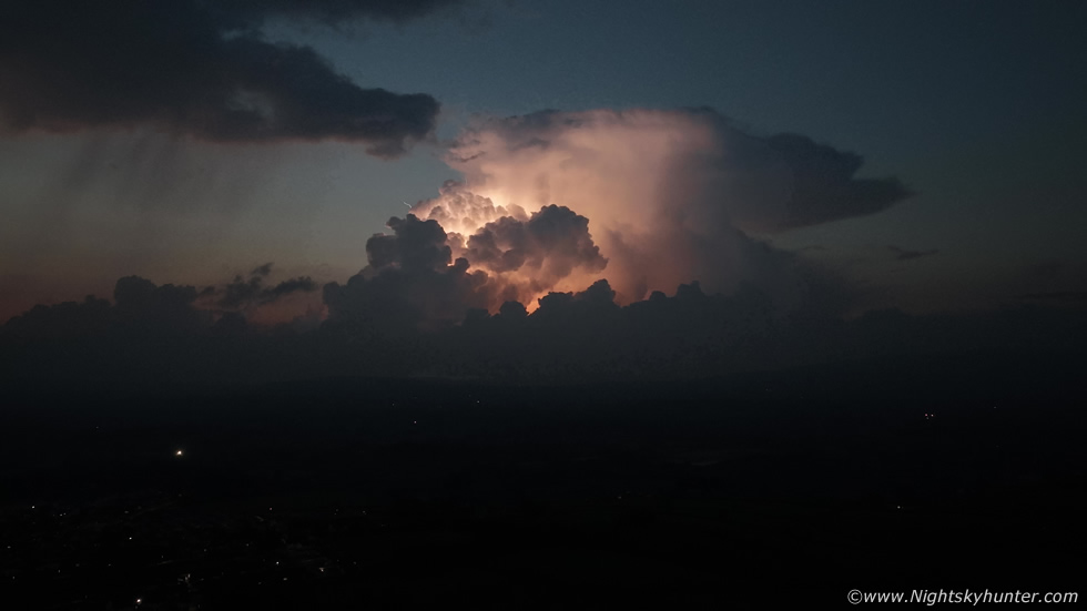
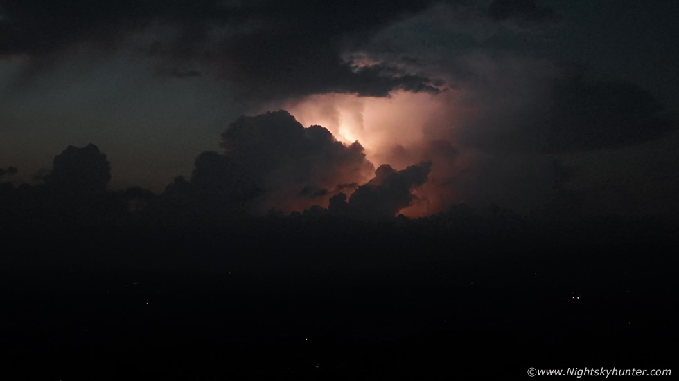
This atmospheric set-up is what's called a 'loaded gun scenario', when you have a big build up of energy capped all day long, then suddenly that inversion is eroded or the air rises through it and you get sudden storm formation, this is called 'explosive thunderstorm development' and that's exactly what was happening now. I had the drone back in the air at 120m and switch to manual settings, I was curious if I would see any lightning at all as it wasn't fully dark yet, in fact, it was still dusk in the process of transitioning to twilight. Then as I casually glanced at the controller screen I saw the tower light up from within, not once, but three times, in quick succession, I was buzzing, I was seeing lightning complete with storm structure by drone in real time from home. I held the controller in through the open window for Roisin to see, and it was still flashing, she was amazed, then she came outside to join me.
 |
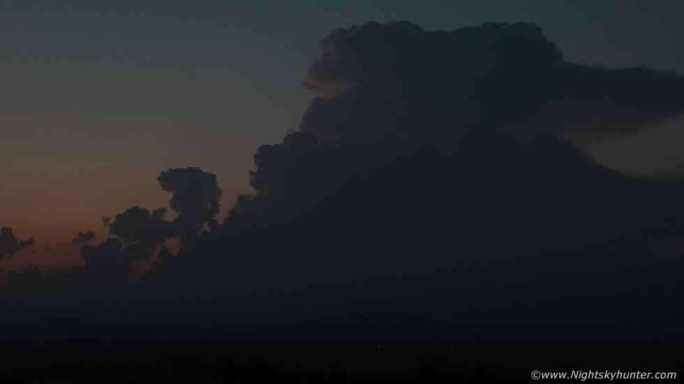
This storm was between 15-20 miles away, and yet it looked big and clearly dominated the twilight sky and it got everyone's attention. Walkers, drivers, people sitting outside having a drink in the heat, anyone who even casually looked to the W out of their window saw this storm and were immediately impressed. What made this storm even more striking was the fact that it was completely isolated, just like the Meath storm, this cell had nothing to compete with so it made full use of the atmosphere to mature into a strong multicell. The sky was entirely clear in all directions so this was the only thing in the sky to draw your attention.
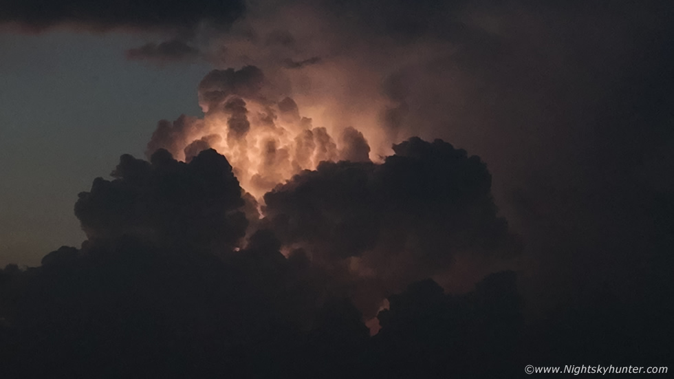
Roisin, Rhua and I walked into the front garden and watched the storm visually, a few houses blocked half of the storm from our view, however the big updraught was visible in a good clear section, and it was here were the majority of the action took place. The primary updraught tower would light up from within, not just flashes of light, but actual visible bolts shooting either up or down or across the storm, the cell was getting lit up like a Christmas tree and it was happening on a regular bases. I began shooting images but then progressed to video just to record this rare event, at first I was on ISO100 with aperture at F/2.8. This scene was the moment when three in-cloud bolts lit up the cell, the bolts tracing their way from the top of the updraught to bottom.
 |
With the Mavic 3 I was able to zoom in and almost full the field, this was the view without any lightning
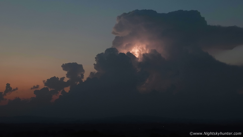 |
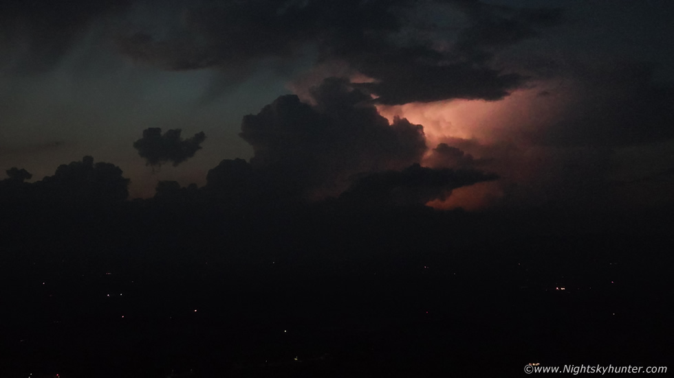
Same view with multiple intra cloud bolts a few seconds later illuminating the updraught towers. Even in this low light you can see just how crisp and solid the convection was, a caliber unheard of in September here, and if that wasn't good enough it was taking place in the late Summer twilight with a persistent orange sunset afterglow still showing its presence in the sky.
 |
Anvil sheared downwind in the direction of travel, the storm was in the process of crossing the Sperrins and would cross the region between Dungiven and Glenshane Pass eventually making its way towards the N coast or Foyle area. This beauty was flashing away, we were standing outside in T-shirts enjoying this rare spectacle while simultaneously feeling astonished with the heat and humidity on a September night, it honestly felt like the Summer was starting all over again.
 |
In proper multicell fashion a new updraught shot skyward in the flanking region, as the sky darkened I was using an ISO between 400 and 800
 |
When I first developed an interest in thunderstorms I always fantasized about watching a big Summer thunderstorm flashing with lightning over the Sperrins in twilight. Back then I lived in Maghera, my bedroom window was large and through it I had a terrific view over the fields and town towards Glenshane Pass and the hills of the Sperrins beyond. On many a Summer night I would sit on a chair and imagine such a scene and how photogenic it would be, however despite many years of storm chasing I never witnessed such a scene. That's not to say there were no storms, there sure was, however getting a warm sector plume multicell visible in dust/twilight in complete isolation with clear sky around the cell was just something you don't see very often in this country, especially during September.
If storms did happen they always happened in daylight and waned as solar heating cooled off, surface based CAPE remaining long after sunset is a rare event inland for the Sperrins, especially into the night. If night storms did happen they were usually associated with elevated convection and hence no cell structure was visible or visibility was greatly reduced by haze, cloud, or rain, so this event truly was rare. My fantasy/dream had come true, I'm no longer in Maghera, however my view from Cookstown is not dissimilar, I'm still facing W over the general direction of the Sperrins, but this time at 45 years of age I was watching the dream through the eyes of a drone in real time, that's something which I never seen coming.
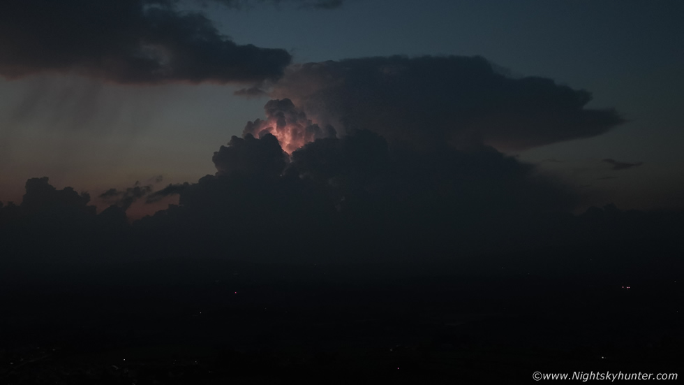
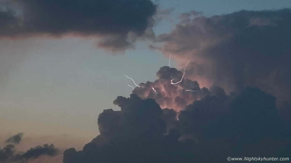
The above image happened when five lightning bolts took place within a 1 to 1.5 sec's illuminating the cell brilliantly. The anvil and updraught were lit up internally and if you look carefully you can see a single cloud to air bolt, something which astonished me, the last time I caught those on camera was during the off-shore supercell event at Mullaghmore in 2013.
 |
I was now on my third drone battery, the sky was dark twilight and I was recording video between ISO1600 and 3200. The night was dead calm with not a breath of wind, the grass dry, the air very warm and close, it was like the perfect Summer's night. Single fainter bolt here, this was full multicell now, the main cell is further away with the classic anvil shape, but that new updraught plume on the flank had just exploded and was now the dominate lightning producer, although both cells were still sparking together.
 |
Keep in mind these are video frames filmed in normal video mode. I could have used night mode for a cleaner brighter image however night mode only works at full wide angle using the full four thirds sensor. In normal mode I can zoom in, so even though the scene is darker and with a little more noise I had the ability to frame the cell better and get in close, I still think the quality is amazing for a drone in these conditions. At this time it was 20 miles away, people were watching it from the N coast.
 |
Cropping into that new updraught plume lit up with intra cloud lightning. I love the contrast between the electrified updraught and those of the dark flanking towers.
 |
Five bolts within a second with an entire cluster of spectacular cloud to air bolts visible against a clear sky. This scene is five video frames stacked together
 |
Deep crop into that updraught with six cloud to air bolts into clear air at the same time, what an amazing sight. I didn't think this night could get any better but it just did rite here.
 |
A proper 20MP still image using the full sensor at ISO1600 for 1.5 sec's at F/2.8 showing the storm in all its glory between lightning discharges, the lights in the distance below are from the outskirts of Cookstown.
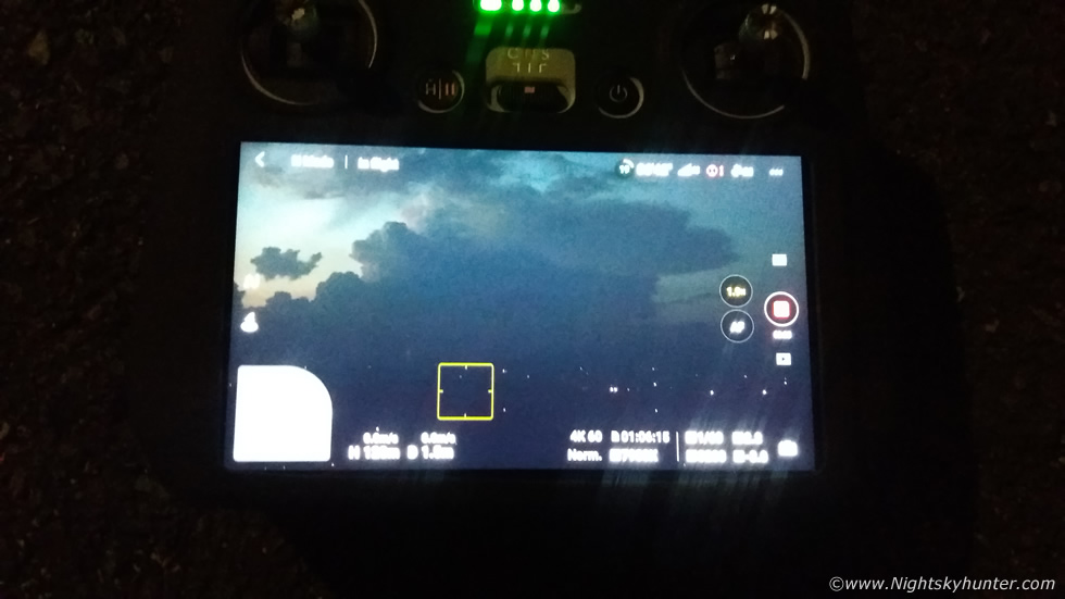 |
Phone snap of the back of the screen, I managed to film a quick vlog while the drone was still in the air and on two occasions I captured lightning live on the RC screen using the phone.
 |
Almost full darkness and the storm was a fair distance away now but the lightning was even brighter but getting to the stage where it was too much for the drone video in normal mode.
 |
One more flash for good measure, the cell was getting too far away, it was crossing the N coast so I landed the drone and stood outside in the front yard watching it flash away and returned inside on an absolute high. I couldn't believe after having such an epic Summer storm season that I just got treated to this, in September!
I uploaded all the images and footage onto an external hard drive just to make sure they were safe, then sat down and relaxed. It as 22.30, the windows were open and the house was very warm. I checked online and wasn't surprised to see social media full of footage and images of this storm, by the looks of things it astonished everyone else as much as it did me. There were images from the Sperrins, Omagh, Maghera, Coleraine, Derry/Londonderry, Dungiven and the north coast, locations to the W/NW actually had the cell illuminated by twilight glow with great updraught structure and very photogenic. I was even amazed to see footage posted on our facebook group from a lady in Scotland who recorded it clearly flashing away against the twilight sky.
I was buzzing for many days after this event, it just ticked so many boxes for me and coincided with amazing weather, this really was a late Summer's night dream come true. For many nights to follow I didn't sleep well, all I could see in my mind was that glorious storm. It was also the talk of the town, many people witnessed it here, there were even reports of witnesses coming into bars informing everyone about the 'heat lightning' going on outside, everyone agreed they had never seen anything like it before in their lives.
Full drone footage of the storm, beginning at sunset with the Meath anvil and Sperrins updraught in the process of breaking the cap then continuing into deep twilight as the tower formed into a beautiful multicell storm, this footage is a combination of three drone batteries and several mobile phone clips. I've edited the footage to showcase the event in a natural way, the footage is intended to be relaxing - what a season!. Thanks very much for reading.
Martin McKenna
